
From early October 2026, the terminology used across Met Office severe weather warnings and Flood Guidance Statements is changing. The Met Office, Flood Forecasting Centre and the UK’s hydrological agencies are introducing a harmonised impact matrix as part of the wider Common Warnings Framework.
The important point is that the matrix itself is not being replaced. It remains a four-by-four framework and the risk colours stay the same. What is changing is the wording used to describe impact, so that weather and flood information is presented more consistently across different agencies.
For responders and emergency planners, the existing terminology already appears in training materials, plans, procedures and decision-making tools, so there is some practical work to do before the change comes in.
What is changing?
The new impact levels will be:
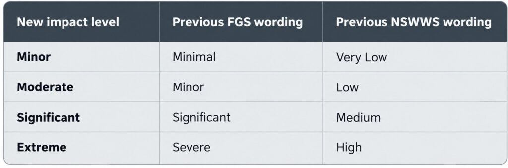
The impacts themselves are not changing. So, for example, what is currently described as a Severe impact in a Flood Guidance Statement will become Extreme. Likewise, what is currently described as High impact in a Met Office warning will also become Extreme.
Another useful part of the change is the way likelihood is presented. The new matrix gives percentage ranges alongside the likelihood terms. An example of the new matrix is below:
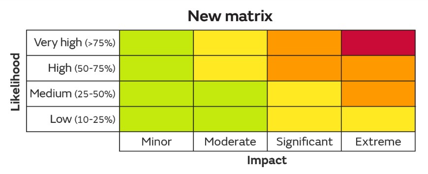
We think this is particularly helpful for responders, emergency planners and other decision-makers. Previously, saying there was a low likelihood of a significant impact left some room for interpretation. “Low” can mean different things to different people. Being able to say there is a 10–25% likelihood of significant impacts occurring gives that discussion a clearer reference point.
It does not remove professional judgement, and the percentage band should not be treated as a precise prediction. But it should make it easier to explain risk, particularly when organisations are deciding whether a response is proportionate. For example, a 10–25% likelihood of significant flooding impacts may still justify preparatory action where the consequences could include danger to life, loss of access routes or disruption to critical infrastructure. That is a much easier conversation to have when both the impact and the likelihood are clearly expressed.
Why this matters
Firstly, training material needs checking.
If you deliver flood response, water rescue, severe weather or emergency planning training, there is a good chance the existing terminology appears somewhere in your material. That could be in slides, instructor notes, scenario packs, exercises, assessment material or aide-mémoires. If a learner is shown a Severe FGS impact in September and then sees Extreme in October, it should be clear that those two terms are referring to the same level within the matrix.
It is a small change, but it is exactly the sort of inconsistency that can create confusion if old and new materials are being used at the same time.
Secondly, emergency plans.
Within Local Resilience Forums and responder organisations, warning terminology can sit inside severe weather plans, multi-agency flood plans, escalation arrangements, tactical plans, briefing templates and decision-support tools. Some organisations may also use warning levels as part of their own operational triggers.
A plan that says “activate X on a Severe impact forecast” may still be operationally sound, but the terminology will be out of date once the new framework is introduced. That is worth picking up before the first significant weather event of the winter.
For LRFs in particular, this is also a useful opportunity to check that partner agencies are all using the same language in plans, training and exercising. The whole point of the Common Warnings Framework is to make warnings easier to understand, share and act upon. That only works properly if our own plans and procedures keep pace with it.
What we are doing at R3 SAR
At R3 Safety & Rescue, we will be reviewing our own training and technical material ahead of the October change. We will also be looking out for the old terminology when reviewing client plans, procedures and emergency arrangements.
For us, the value of the change is not simply that everyone will use the same four words. It is that responders, planners and partner organisations should have a clearer common language for discussing both impact and likelihood, and for making proportionate decisions.
If you work in emergency planning, flood response, resilience or severe weather planning, now is a good time to check where the existing terminology appears in your training, plans and procedures and make sure they are ready for October.


